


Precinct 12, West Carroll Parish, Louisiana
About
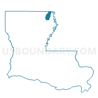
Outline

Summary
| Unique Area Identifier | 591375 |
| Name | Precinct 12 |
| County | West Carroll Parish |
| State | Louisiana |
| Area (square miles) | 3.02 |
| Land Area (square miles) | 3.02 |
| Water Area (square miles) | 0.00 |
| % of Land Area | 100.00 |
| % of Water Area | 0.00 |
| Latitude of the Internal Point | 32.87352330 |
| Longtitude of the Internal Point | -91.37032520 |
Maps


Graphs
Select a template below for downloading or customizing gragh for Precinct 12, West Carroll Parish, Louisiana


Neighbors
Neighoring Voting District (by Name) Neighboring Voting District on the Map
- Precinct 10, West Carroll Parish, LA
- Precinct 11, West Carroll Parish, LA
- Precinct 14, West Carroll Parish, LA